This summer I intend to take a three month, 1,200-mile walk from south to north Britain. This walk is commonly referred to as Land’s End to John o’ Groats or “LEJOG.” There is no set LEJOG path. The walker must make their own route between the two points. I’ve cobbled together a network of footpaths that will take me from the most south-westerly tip of England to the most north-easterly tip of Scotland. More accurately, I’ve cobbled together a number of potential paths I could take through the country, picking and choosing as I go. A true ramble.
 While I intend to walk mostly alone, there are a number of people who have expressed interest in joining me for a portion of my ramble. This is my attempt to accommodate as many people as possible. If you want to join me, I’ve identified two very different areas that would be ideal. Unfortunately, I think the dates and itineraries are firmly set.
First option: Cotswolds

Bibury. One of the many stunning villages on the Cotswolds route.
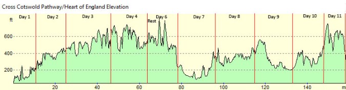
Trail: A portion of the Cross Cotswolds Pathway and most of the Heart of England Way, verring off the Heart of England Way the last day to end in Burton-Upon-Trent.
Distance: 160 miles**
Duration: 11 days (excluding travel to and from the trail). 10 Walking days, a rest day on the 5th day.**
Dates: July 12th-July 22nd** (excluding travel to and from the trail).
Starting location: Bath, England.
Recommended Aiport: London Heathrow or Gatwick.
Minimum Required Number of Participants: 3, excluding me.
Grade: Easy to moderate.
Description: Relatively flat walk through the bucolic English countryside, front-loaded with the most picturesque English villages in the county.
Pros:
- Classic English villages. It’s Thomas Kinkade’s wet dream.
- Extremely picturesque with a ton of history along the trail.
- Bath is very easy to get to from London with a busy train station in the town center. About 2 hours from London by train. Bath is also a fun city with lots of great beer and historical sites.
- A very mild walk. Not nearly as hilly as the alternative Pennine route.
- More villages and cities along the trail.
- If you become injured, it would be very easy to cab to the next accommodation.
- Ending in perhaps the most important beer city in history, Burton-Upon-Trent.
- Burton-Upon-Trent to London train takes 2-3 hours.
Cons:
- Can be touristy.
- The villages will be close to the height of tourist season and they are prone to overcrowding.
- Baggage transfer could be costly if not shared among more than a couple people.
- There’s a chance that I would not be there to start the trail with you but would meet you just a few miles in.
Specific Highlights:
- Bath
- Castle Combe
- Tetbury
- Bibury
- Bourton-on-the-Water
- Upper and Lower Slaughter
- Stow-on-the-Wold
- Stratford Upon-Avon (short detour, birthplace and home of Shakespeare)
- Burton-Upon-Trent and the National Brewing Centre.
- 2008, 2014 and 2015 CAMRA National Pubs of the Year a short drive from the trail.
Itinerary:**
| Day | Start | Finish | Milage |
| Thurs, July 12 | Bath | Castle Combe | 11 |
| Fri, July 13 | Castle Combe | Tetbury | 14 |
| Sat, July 14 | Tetbury | Bibury | 20 |
| Sun, July 15 | Bibury | Bourton | 18 |
| Mon, July 16 | Rest | Rest | 0 |
| Tues, July 17 | Bourton | Chipping Campden | 15 |
| Wed, July 18 | Chipping Campden | Snitterfield | 18 |
| Thurs, July 19 | Snitterfield | Balsall Common | 20 |
| Fri, July 20 | Balsall Common | Kingsbury | 18 |
| Sat, July 21 | Kingsbury | Litchfield | 15 |
| Sun, July 22 | Litchfield | Burton-Upon-Trent | 13 |
** This route can be conveniently cut short for anyone who cannot commit to 11 days. The route skirts many larger towns and cities with train stations, making for an easy ride back to any airport. The most interesting bits of this route are in the first half.
Second Option: Yorkshire Dales
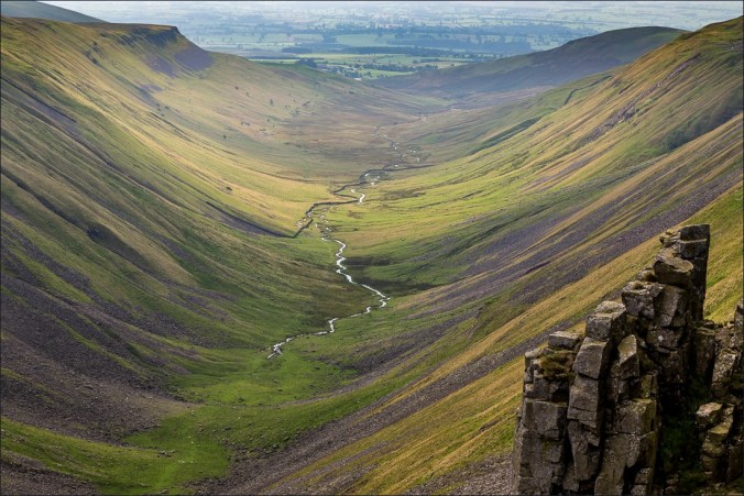
High Cup Nick. The Pennines are known for their rugged isolation.
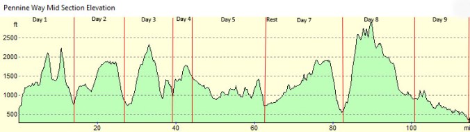
Trail: Middle portion of the Pennine Way.
Distance: 117 miles.
Duration: 9 days (excluding travel to and from the trail). 8 walking days, 1 rest day.
Dates: August 3 – August 11 (excluding travel to and from the trail).
Starting location: Malham, England
Recommended Aiport: Manchester, Leeds or Edinburgh (occasionally you can acquire very inexpensive tickets through Edinburgh)
Minimum Required Number of Participants: 2, excluding me.
Grade: Challenging.
Description: My favorite area in England. Rugged and remote with sparse rustic villages.
Pros:
- Amazing vistas and some of the most stunning landscapes in England.
- Less touristy.
- Pubs with more character.
- Friendlier locals.
- Allows you to fly in and out of Manchester, which I find more fun than London.
- Haltwhistle (where you finish) 2 hours from Manchester, 3 to Edinburgh or Glasow and just over an hour to Newcastle, each by train.
Cons:
- Very hilly with significant daily ascents and descents. Considerably more difficult than the Cotswolds route.
- Less history, although this portion of the walk will end near Hadrian’s Wall.
- Desolate and lonely in many places. Fewer villages. There may not be many places to stop for lunch.
- Prone to extreme bogginess.
- No direct train to Malham. The closest station is 7 miles away. You’ll have to cab it from there. There is a train station in the ending village.
Specific Highlights:
- The Pennine Cup Nick
- Hadrian’s Wall
- Hawes
- Tan Hill Inn
- Green Dragon Inn
- High Force
- 2016 National Pub of the Year cabbing distance off the trail.
Itinerary:
| Day | Start | Finish | Milage |
| Fri, August 3 | Malham | Horton in Ribblesdale | 15 |
| Sat, August 4 | Horton in Ribblesdale | Hawes | 13 |
| Sun, August 5 | Hawes | Muker | 11 |
| Mon, August 6 | Muker | Tan Hill | 6 |
| Tue, August 7 | Tan Hill | Middleton in Teesdale | 18 |
| Wed, August 8 | Rest | Rest | 0 |
| Thurs, August 9 | Middleton in Teesdale | Dufton | 20 |
| Friday, August 10 | Dufton | Alston | 19 |
| Sat, August 11 | Alston | Haltwhistle | 15 |
FAQ
General Information
If you have not done so already, skim through my blog posts about English walking tours here. Those posts contain more general information.
How fit should I be?
While these walks can be tough at times, requiring strenuous physical exertion, they do not require an advanced level of fitness. I once ran into a group of rotund American women near 60 years old on the last few miles of an 80-mile path. They were no athletes. This is not backpacking. Your luggage will be transferred from accommodation to accommodation daily. You will only need to carry a day pack with a few essentials. That being said, if you are not active in some way, training is highly recommended. We will be covering a lot of miles day after day. The cumulative effect on your body can become overwhelming if you are completely unconditioned.
The Pennine route will be significantly more challenging than the Cotswolds route. If you are concerned about joint issues, seriously consider whether you are up for the daily ascents and descents of Pennine route. It will require significantly more fitness than the Cotswolds route. Consult the elevation profiles posted above.
What does an average day look like?
An average day will look something like this: wake up just before 8am, eat breakfast, pack and hit the trail about 9am. Three or four hours of walking, covering 6-12 miles before we stop for lunch. After lunch, it will be another 3 to 4 hours of walking, covering another 6-12 miles before we arrive at our destination. On occasion, there will be the odd village or historical site thrown randomly into the mix, adding another hour or two to the day.
When we get to the accommodation, most of us will stop for a beer and a snack and then retire to the room for a shower or short nap before dinner. The whole group will usually get together for dinner around 7. Most nights, we will be in the pub until about 11pm.
Rest days are scheduled in places with more facilities than your average village. Very likely rest days will also include a half an hour cab ride to a notable pub or two.
What is the cost?
Based on my experience, assuming the pound does not shoot up in value, and excluding the cost of the flight, $2,500 should cover all costs of two weeks of balls to the wall partying. This is a ceiling, not a floor. You can certainly do it for less, and I usually do. But when traveling with a bunch of thirsty friends, the nightly bar tabs can climb. The bulk of the cost will be for food and drink, which of course are completely within your control.
I will arrange accommodations, baggage transfer and help with group travel logistics. I may require upfront payment for certain costs but the bulk of accommodation costs will be payable to the accommodation during our stay. Everything will be clearly accounted for.
What is the cost of your services?
$100 a person. Besides setting up the accommodations and arranging baggage transfer, the simple fact is that I budgeted to camp most of my three months. If I throw in 20 nights of accommodations, it quickly puts me over budget. The $100 helps offset some of that additional cost. If there are not enough participants for a route option, I will likely cancel that option.
Every participant should know that I do not intend to be your guide except in the loosest sense of the word. There may be days where I need to be by myself and I will just point you in the direction you need to go and make sure you have what you need to get there. If you get hurt or want to skip a day, you will be expected to make your own arrangements. That being said, I’ll make sure there will always be somewhere to eat lunch (and if not, arrange for sack lunches) and a bed and a meal at the end of the day.
What gear do I need?
No need to go too crazy on gear. You’ll need adequate rain gear and decent hiking attire. Hiking poles in the Pennines are highly recommended. Comfortable hiking footwear, whether boots or trail runners, is essential. Do not show up with unbroken in footwear. It should be noted that you will not need to carry luggage on the trail. We will hire people to pick up and drop off at each day’s accommodation. For more specifics about gear, see the gear section of this blog post.
What about accommodations?
We will share accommodations to keep costs low. It’s usually two or three people to a room, each with their own bed. We will stay at family-run bnbs or inns most of the time with and an occasional hotel. Breakfast is almost always included. To the extent that there are single occupancy rooms included in the group of rooms, they will be split equitably among individuals in the group.
What if I get injured?
Firstly, I strongly recommend every person acquire travel insurance. I’ve never had to use it but I think it would be tempting fate to walk without it, particularly in the Pennines. Besides the many other benefits of travel insurance, evacuation services are probably the most relevant. Should you get hurt on some lonely fell peak, you’ll be covered. Insurance for 2 weeks should run from $100-$175.
If you get hurt on the trail, you’re often never more than a few miles from civilization. Once there, you will need to arrange transportation to our next stopping point and repeat until you are up for more walking. Even if you are just tired or bored of walking, you can always skip a day by arranging your own transportation.
Can I join you somewhere else on your LEJOG route?
Very likely not. Not only do I relish my time alone but I intend to keep a loose schedule, walking where I want on a day’s whim. I will be camping most of the time, except during these group route portions.
Can I bring my spouse or friend?
Yes. As long as they can keep up and are not easily offended by a group of foul-mouthed and beer thirsty men.
When do I need to commit?
While you can choose to come up until the last minute, if you want my help setting everything up, I’ll need to know who’s in by mid-May. This will allow me time to get everything worked out before I leave for my walk. If you can’t commit by then, you can always try to make your own arrangments. However, you run the risk of not staying at the same accommodations as the group or, even worse, not being able to book accommodations in the same village. Because you will be booking a room for yourself, your cost will be more than it would be if pooling the cost.
How many travel days do I need to get to and from the trail?
I recommend four days: two to depart and get from where you land to the starting point and two to get from the finishing point to the airport and home. On the front end, flights are often late so it may not be feasible to get all the way to the starting point on the same day you land (although, this should not be a problem with Bath if you get in anytime during or before the afternoon) so that extra day gives you a buffer in case something goes awry. On the back end, having a day to get to your departure city saves you from worrying about late trains and a very long travel day. It also provides you with an opportunity to explore your departure city. You could certainly try to catch a flight the day after you’re done walking if your flight left in the afternoon. If you took my four-day advice, the entire Cotswolds route would require 15 days and the Pennine route, 13.
I’m interested. What now?
Let me know whether there’s a route you’re interested and I will send you an invite to a facebook group where we can work out all the details in a group setting. DO NOT PURCHASE plane tickets or any other big ticket items until all details have been confirmed.

